1
Stuttgart Hiking Trail
Field Guide

2
Table of Contents
1. Stuttgart History
2. Stuttgart Hiking Trail
Hikers are reminded to observe all local German laws and
customs, including crossing the street at crosswalks. Stuttgart Mitte is
under heavy construction at the time of this writing, therefore,
deviations from the intended route may be necessary for safety. Always
ensure that you are dressed appropriately for the weather and have
adequate water for your hike. Above all, have fun!
3
Stuttgart
The first inhabitants settled this fertile land near the Neckar River
now called Stuttgart. The subsequent settlers were Romans occupying
and invading German provinces in an effort to expand the Roman
Empire. In doing so, they founded a fort in present-day Bad Cannstatt,
currently a district in Stuttgart. In A.D. 950, Stuttgart turned into a stud
farm for breeding horses for the Duchy of Württemberg. Half a
millennium later, Stuttgart became the capital of the Duchy of
Württemberg in 1482 and later became the capital of the Kingdom of
Württemberg under Napoleonic rule. The 19
th
and 20
th
centuries were a
turbulent time for Stuttgart, with the most significant impacts resulting
from the Allied bombing of critical industrial and military targets in the
area during World War II. After the war, the city rebuilt many of its
buildings using primarily modern-style architecture, but some old
architectural styles were also used, such as Bauhaus, Baroque, and
Rococo. Currently, under Stuttgart 21, the Baden-Württemberg
parliament and mayor are overseeing renovations designed to revitalize
city architecture to compete with other German cities, such as
Hamburg, Lübeck, Berlin, Munich, Cologne, Frankfurt, and Dresden.
Stuttgart is a wonderful city with lots to see and do and offers a
great chance to experience German and Swabian culture amid the
classical architecture of the old town. Stuttgart has preserved its
palaces and castles while tastefully building modern, functional
structures, including the Bibliothek, the Porsche museum, and the
Stuttgart VFB soccer arena. It truly is a wonderful city with a unique
and vibrant culture that is centuries old and easily discoverable.
Exploring Stuttgart and completing the hike will take approximately 2-
3 hours and cover a total distance of about 5 miles.

4
Hauptbahnhof
Checkpoint #1
Arnulf-Kletz Platz 2
70173 Stuttgart
GPS Coordinates: 48°46’56“ N 9°10’54“ E
Elevation: 250 meters
https://www.bahnhof.de/bahnhof-de/bahnhof/Stuttgart-Hbf-1038338
Paul Bonatz built the Hauptbahnhof, or central train station, for
the Kingdom of Württemberg, in 1914, and the station came into
service in 1922. In 1933, the Deutsche Reichsbahn electrified the
Hauptbahnhof. The Hauptbahnhof was constructed in the architectural
style of the Renaissance Revival and is currently under refurbishment
and renovations under the Stuttgart 21 Project.
In World War II, the Allies targeted the Hauptbahnhof in many
bombing raids on Stuttgart because it was a center for logistics and
communications. The Nazis built a decoy at Lauffen am Neckar to
protect the station from air raids between 1940 to 1942.
Despite the decoy, Allied air raids from British and American
heavy bombers severely damaged the Hauptbahnhof. Following World
War II and during the Cold War, the United States occupied Stuttgart
under the Four Powers’ Agreement. In 1971, plans to build the modern
S-Bahn (Stadt Bahn) started, and construction finished in 1978. As part
of the new Stuttgart 21 construction project, the renovated
Hauptbahnhof will add new tracks and platforms and will be able to
accommodate more trains, including a new high-speed European train
route from Paris through Stuttgart to Vienna. This will improve
passenger transport across southern Germany and Europe.

5
Stadtbibliothek
Checkpoint #2
Mailander Platz 1
70173 Stuttgart
GPS Coordinates: 48°47’25“ N 9°10’59“ E
Elevation: 260 meters
Documentation: Mon - Sat 09:00 - 21:00, closed Sun
http://www1.stuttgart.de/stadtbibliothek/
In 2011, Stuttgart completed the Stadtbibliothek, or City Public
Library, at the cost of 80€ million. Eun Young Yi designed the library,
which welcomes 2 million visitors per year. Home to 60,000 books and
four stories high, the library is designed as a cube of white block brick
with squares and panes of glass. This vantage point provides a full
view of the Neckar Valley, Stuttgart, and its suburbs. The original
library in Stuttgart was built in 1834 and was previously housed in the
Wilhelm Palais.

6
Staatsgalerie
Checkpoint #3
Museum Der Bildenden Künste
Konrad Adenauer Straße 30-32
70173 Stuttgart
GPS Coordinates: 48°46’51“ N 9°11’9“ E
Elevation: 250 meters
Documentation: Open Tues - Sun 10:00 - 17:00 PM, and Thurs 10:00 - 20:00, closed Mon
https://www.staatsgalerie.de/
The State of Baden-Württemberg first built the Staatsgalerie, or
State Gallery, as the Royal Art School and a cultural enrichment
project. Finished in 1843, it houses famous paintings by Italian, Dutch,
and German artists.
After suffering extensive damage during World War II, it was
rebuilt in 1947 and reopened in 1987. It contains both new and old
works, including artwork by Pablo Picasso, most of which are
renaissance or classical styles. It also includes beautiful depictions of
abstract and modern art.

7
Staatstheater
Checkpoint #4
Oberer Schlossgarten 6
70173 Stuttgart
GPS Coordinates: 48°46’48“ N 9°11’2“ E
Elevation: 220 meters
Documentation: Tickets can be purchased by calling this phone number: 0711-202090
https://www.staatsoper-stuttgart.de/en/
Max Litmann designed the Staatstheater, or State Theater, which
was built between 1909-1912. The drama section of the building
suffered immense damage during World War II and was later rebuilt
under the direction of Hans Volkart between 1959-1962. Between
1982-1984, Stuttgart modernized the original structure but
subsequently restored it to its previous form of architectural elegance.
The theater is still open today, hosts concerts, operas (including
operas for children), ballets, and other performances. It specializes in
highlighting German culture, such as the fairy tales of the Black
Forest.

8
Haus der Geschichte Baden-Württemberg
Checkpoint #5
Konrad Adenauer Straße 16
70173 Stuttgart
GPS Coordinates: 48°46’44“ N 9°11’15“ E
Elevation: 260 meters
Documentation: open Tues - Sun 10:00 - 18:00, Thurs 10:00 - 21:00, closed Mon
https://www.hdgbw.de/english/
Stuttgart first built the Haus der Geschichte Baden-Württemberg,
or House of History of Baden-Württemberg, to educate tourists and
others about the Swabians’ history and the state of Baden-
Württemberg from the Napoleonic Wars to modern-day Stuttgart. The
museum is entirely dedicated to the history of the state of Baden-
Württemberg.

9
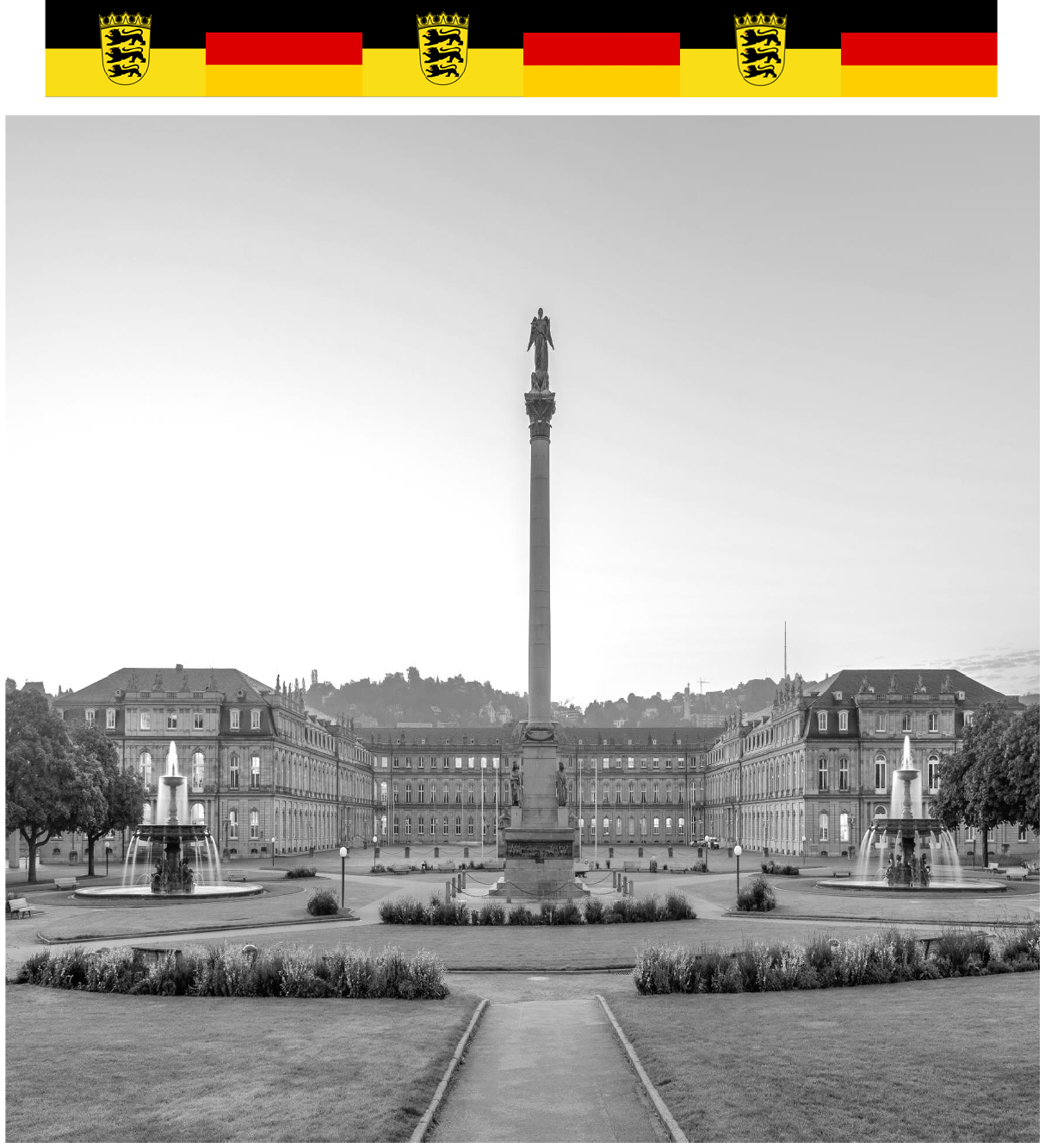
Neues Schloss
Checkpoint #6
Schlossplatz
70173 Stuttgart
GPS Coordinates: 48°46’43“ N 9°10’59“ E
Elevation: 260 meters
https://www.neues-schloss-stuttgart.de/start
The Württembergs first built the Neues Schloss, or New Palace,
between 1746-1807 as a residence for the Dukes and Kings of
Württemberg. Famous royals and monarchs from all over Europe
visited the palace, including Russian Tsars Paul I and Alexander I, and
the French Emperor Napoleon Bonaparte.
During World War II, the Luftwaffe used the Neues Schloss as an
air control headquarters until it was bombed during an air raid.
Stuttgart later rebuilt the palace following a vote by Baden-
Württemberg’s Parliament. The vote succeeded by one vote. Today the
palace is the home to the state's ministry of finance.

10
Schlossplatz
Checkpoint #7
Schlossplatz
70173 Stuttgart
GPS Coordinates: 48°46’43“ N 9°10’59“ E
Elevation: 260 meters
https://www.stuttgart.de/tourismus/sehenswuerdigkeiten/schlossplatz.php
The Schlossplatz, or Palace Square. is the inner courtyard of the
Neues Schloss and the center of Stuttgart. On sunny days, residents
and tourists alike can be seen sunbathing and enjoying the square,
including the nearby restaurants and cafes. In the winter, it is home to
part of the Christmas Market.

11
Königsbau
Checkpoint #8
König Straße 26
70173 Stuttgart
GPS Coordinates: 48°46’45“ N 9°11’46“ E
Elevation: 260 meters
Documentation: open all days 10:00 - 21:00 except Sun
https://www.koenigsbau-passagen.de/
The Swabian King, Wilhelm the 1st, and architects Christen
Friedrich von Leins and Michael Johann Knapp built the Königsbau, or
Royal Building as a business, concert hall, and ballroom between the
years of 1856-1860. Today, with a rebuilt façade based on the original
design, it is used as an eatery and shopping area for central Stuttgart.

12
Landesmuseum
Checkpoint #9
Schillerplatz 6
70173 Stuttgart
GPS Coordinates: 48°46’37“ N 9°10’44“ E
Elevation: 250 meters
Documentation: open 10:00 - 17:00, Tues – Wed, 10:00 - 21:00 Thurs, 10:00 - 18:00, Fri - Sun , closed Mon
https://www.landesmuseum-stuttgart.de/
King Wilhelm the 1st founded the Landesmuseum, or State
Museum, in 1862 as a museum of culture and history. It inspired
patriotism for local residents and promoted tourism about the culture
of the Kingdom of Württemberg.

13
Schillerplatz
Checkpoint #10
Schillerplatz
70173 Stuttgart
GPS Coordinates: 48°46’37“ N 9°10’44“ E
Elevation: 250 meters
https://www.stuttgart-tourist.de/en/a-schillerplatz-stuttgart
Duke Frederick ordered Schillerplatz, or Schiller Square, to be
built in 1607. Schiller was also a philosopher, poet, playwright, and
historian. After disagreeing with Duke Carl Eugene, Schiller escaped
Stuttgart under a false name with a trusted friend. The statue in the
Platz is in honor of the hometown patriot and regimental doctor for
Württemberg, Friedrich Schiller. A Danish architect designed the
statue, and cast it from the metal from cannons from the city of
Munich in 1839. The square was officially renamed Schillerplatz in
1934.

14
Stiftskirche
Checkpoint #11
Stiftsraße 12
70173 Stuttgart
GPS Coordinates: 48°46’37“ N 9°10’44“ E
Elevation: 250 meters
Documentation: open 10:00 – 19:00 Mon – Thurs, 10:00 - 16:00 Fri - Sat, Closed Sun
https://stiftskirche.de/
The Counts of Württemberg built the Stiftskirche, or Collegiate
Church, in 1240. It houses the remains of Count Ulrich’s first and
second wives, who both died in 1265. The Stiftskirche is an
Evangelical or Protestant church in Catholic-dominated southern
Germany. In 1534, this church was reformed according to the
Protestant and Lutheran doctrines, as the Reformation gained
popularity. In 1944, the Allies accidentally bombed the church, but it
was rebuilt in the 1950s, maintaining the original exterior façade with
a modern interior.

15
Stauffenberg-Erinnerungsstätte
Checkpoint #12
Near the Landesmuseum
70173 Stuttgart
GPS Coordinates: 48°46’37“ N 9°10’49“ E
Elevation: 273 meters
https://www.hdgbw.de/ausstellungen/stauffenberg/
The Stauffenberg-Erinnerungsstätte, or Stauffenberg Memorial, is
dedicated to Count Claus von Stauffenberg of Germany. He opposed
the Nazi regime and attempted to kill Hitler in the Wolf’s Lair, a
fortified Nazi headquarters with camouflaged bunkers. It still exists in
modern-day Gierloz, Poland. Stauffenberg’s team planted a bomb in a
briefcase and left just before it blew up.
The bomb killed and maimed several high-ranking Nazis but ultimately
failed in its goal to kill Hitler. Stauffenberg’s team was later captured
and executed.
Famous movies including,
Valkyrie
,
Operation Valkyrie
,
The Plot
to Assassinate Hitler
, and
The Plot to Kill Hitler
, have been made
about Stauffenberg and his efforts. They depict Stauffenberg’s
attempts, failures, and efforts to seize control from Hitler and the
Nazis.
The inscription between the blocks in the memorial reads
“Vervemt, verstossen, gemartert, erschlagen, erhaengt, vergast.
Millionen Opfer der nationalsozialistischen Gewaltherrschaft
beschwoeren dich Niemals Wieder!” or “Condemned, violated,
martyred, slayed, hung, gassed. Millions of victims of the National
Socialist tyranny swear never again!”

16
Kaiser Wilhelm I Denkmal
Checkpoint #13
Karlsplatz
70173 Stuttgart
GPS Coordinates: 48°46’35“ N 9°10’50“ E
Elevation: 267 meters
https://www.stuttgart.de/vv/adresse/kaiser-wilhelm-i.von-friedrich-von-thiersch-1897-98-.php
The Kaiser Wilhelm I Denkmal, or Emperor Wilhelm I Memorial, is
dedicated to the first Kaiser of Germany, who, along with Otto Von
Bismarck, executed a series of wars that ultimately unified Germany
under Prussian rule. Prussia invaded Denmark in 1864, annexing
Danish territory and establishing the future German state of
Schleswig-Holstein. In 1866, Prussia invaded Austria-Hungary, which
at the time was the predominant German-speaking empire. In the third
and final war, France declared war against Prussia on July 16, 1870,
and invaded German territory on August 2, 1870. Each independent
German state declared war against France, the Prussians defeated
France and unified Germany in 1871.
As a result of the victory over France, Germany stripped France
of Alsace and Lorraine; two border provinces transferred back and
forth between France and Germany over hundreds of years. The
transfer of these two provinces in 1871 furthered the long-standing
grudges between both nations and would influence the conditions that
led to World War I.
Kaiser Wilhelm was an essential leader to Germany. However, he
was not as powerful as Bismarck, the preeminent European statesman
of his time.

17
Markthalle
Checkpoint #14
Dorotheenstraße 4
70173 Stuttgart
GPS Coordinates: 48°46’35“ N 9°10’49“ E
Elevation: 286 meters
Documentation: Open 07:00 - 17:00 Sat, 07:30 - 18:30 Thurs - Wed, Closed Sun
https://www.markthalle-stuttgart.de/en/
Stuttgart built the Markthalle, or Market Hall, in 1914 and had it
decorated with large paintings of artisans, merchants, and other
tradespeople selling goods and wares. The images can still be seen
outside the building, a tradition in Stuttgart that hasn’t been lost to the
ages. Today, in the Markthalle, they still sell goods and other items for
people to buy, such as fresh fruit and honey, to meats and fish.

18
Marktplatz
Checkpoint #15
Marktplatz
70173 Stuttgart
GPS Coordinates: 48°46’38“ N 9°10’49“ E
Elevation: 246 meters
http://www.elivewebcams.com/stuttgart-marktplatz-webcam-live/
The Marktplatz, or Market Courtyard, is the Stuttgart city center
and is bordered by the Rathaus. It sits on top of a large bunker
complex from World War II, a bomb shelter protecting the city’s
residents against American and British air raids. This bunker complex
was used as housing after the war and can be visited only once a year
in December. In addition to the bunker complex, there are other
reminders of Stuttgart’s Nazi and wartime past, such as the stumbling
stones or Stolpersteine. These brass-covered cobblestones remind
Jewish residents who were deported from Stuttgart to concentration
camps and death camps in World War II.
Despite these grim reminders, the Marktplatz maintains its
principal function in the city and is surrounded by many fine stores and
shops. It is another location for the city’s Christmas Market in the
winter. One of the stores in the Marktplatz is the fine porcelain store
Meissen, a Saxon porcelain company that produced the first stiff paste
porcelain in Europe. Meissen discovered this type of porcelain, which
rivaled the latest technology in China at the time. Meissen has been
used to decorate many palaces throughout Europe, such as the Saxon
Zwinger palace in Dresden.

19
Rathaus
Checkpoint #16
Marktplatz 1
70173 Stuttgart
GPS Coordinates: 48°46’20“ N 9°10’42“ E
Elevation: 253 meters
Documentation: Open 08:00 - 18:00 Mon-Fri, Closed weekends
https://www.stuttgart.de/rathaus/
The Rathaus, or Stuttgart City Hall, borders the Marktplatz, the
main square of Stuttgart. The original Rathaus of Stuttgart was
bombed During World War II and damaged beyond repair. It was rebuilt
as a modern facility in the 1950s. The Rathaus displays an Advent
Calendar in its windows during the Christmas season, each office
window showing a different day.
In addition, the Rathaus houses a unique type of elevator, the
Paternoster. The Paternoster is a perpetually moving elevator. It does
not have doors that open and shut like modern elevators. Instead, you
step on and off when it reaches your floor. It was built in 1956 by the
Zuffenhausen machine factory. A few years ago, the German Federal
government tried to shut down the Paternoster. Still, the ban was
overturned after only a few weeks, leading to the Paternoster’s return
as the elevator for the Rathaus.

20
Stuttgardia
Checkpoint #17
Stiftstraße 12
70173 Stuttgart
GPS Coordinates: 48°46’31“ N 9°10’40“ E
Elevation: 300 meters
https://www.stuttgart.de/vv/adresse/heinz-fritz-standbild-stuttgardia-1905.php
In the 19th Century, Stuttgart made plans to build a new
Rathaus, or Town Hall. Stuttgart commissioned a statue of the city’s
Patron goddess for this beautiful new building, called Stuttgardia. All
German cities have patron gods and goddesses to portray the towns
and their traits, such as a port city would have a statue related to
water. So Stuttgardia proudly hung off the walls of the Rathaus until
severe heavy bombing wrecked the building. Stuttgardia fell off the
building but was left undamaged. The Swabians dutifully restored their
patron goddess to the newly constructed Rathaus in 1956, where it
still stands today.

21
Maps

22
Maps (Cont.)

23
Pictures
1. Main Train Station 2. City Public Library
Left the Stuttgart Hauptbahnhof as seen today, and the Wurttemberg Bahn plaque from 1920.
3. State Galerie 4. State Theater
5. House of History 6. New Palace
24
Pictures (Cont.)
7. Palace Square 8. Royal Building
9. State Museum 10. Schiller Square
11. Collegiate Church 12. Stauffenberg Memorial

25
Pictures (Cont.)
13. Kaiser Wilhelm Memorial 14. Market Hall
15. Market Courtyard 16. Town Hall
17. Stuttgardia

26
Ryan M. Healy created the Stuttgart Hiking Trail for
his Eagle Scout project as a member of Troop 324,
Edelweiss District, Transatlantic Council.
November 28, 2021
